{{ ctx.nhits | number }}
record
{{ ctx.nhits | number }} record
Active filters
No active filters
Filters
Cultuurhistorie
De cultuurhistorische waardenkaart is door de gemeenteraad als beleidskader vastgesteld bij besluit van 18-03-2008. De gemeenteraad heeft bij besluit van 29-11-2022 de cultuurhistorische waardenkaart gewijzigd.
In 2022 is een nieuw onderdeel aan de cultuurhistorische waardenkaart toegevoegd, bestaande uit Landschappen, Nederzettingen en Elementen (lijn, punt en vlak). De deelthema’s Stedebouw & Stadsgezichten, Weg- en waterenstructuur en Landschap & Groen zijn te vinden onder 'Historische stedenbouw en erfgoed'. Dit zijn oudere onderdelen van de cultuurhistorische waardenkaart, naast thema’s als monumentale bomen, rijks- en gemeentelijke monumenten en de archeologische verwachtingsgebieden. Voor meer informatie over de inhoud van deze thema’s is onderaan een toelichting op de thema’s te vinden.
Zie ook de webapp via https://experience.arcgis.com/experience/7b7618385ff14d96bd80a1f12ca530c4/page/Page/
Inleiding
Op 29 november 2022 is de cultuurhistorische waardenkaart van Eindhoven geactualiseerd. De kaart dient als beleidskader om bij ruimtelijke ontwikkelingen in de stad om rekening te kunnen houden met de cultuurhistorie van Eindhoven. De kaart bestaat uit twee deelwaardenkaarten, te weten de waardenkaart historisch cultuurlandschap en de waardenkaart historische stedenbouw en gebouwd erfgoed.
Waardenkaart historische cultuurlandschap
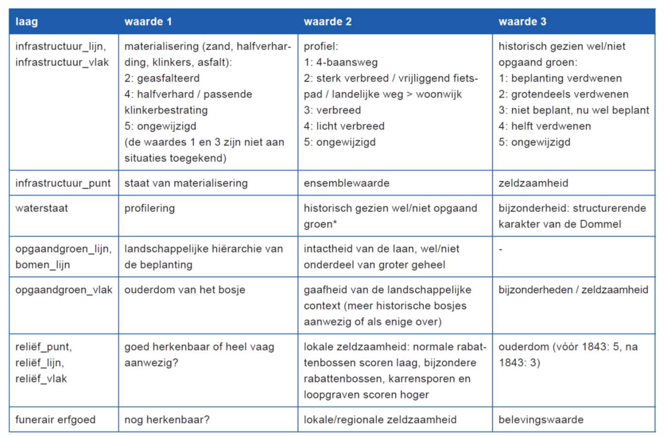
Op de waardenkaart historisch cultuurlandschap zijn aangegeven en gewaardeerd de historische landschappelijke gebieden (incl. historische nederzettingslocaties) en elementen (landschapselementen infrastructuur, waterstaat, opgaand groen, religie en funerair erfgoed en reliëf), die belangrijk zijn voor de herkenbaarheid van de historische ontwikkeling van Eindhoven.
Deze waardenkaart vormt het resultaat van twee onderzoeken van RAAP Archeologisch Adviesbureau BV, te weten:
- Rapport buitengebied: ‘De groene zoom van Eindhoven; een cultuurhistorische waardenkaart van het buitengebied van Eindhoven, alsmede enkele groene delen van de bebouwde kom’;
- Rapport stedelijk gebied: ‘Het landschap onder de stad. Een cultuurhistorisch onderzoek naar de relicten van het prestedelijk landschap in het stedelijk gebied van de gemeente Eindhoven’.
Op de waardenkaart zijn van de waardenkaarten van deze twee onderzoeken aangegeven de midden, hoog en zeer hoog gewaardeerde landschappen/nederzettingen in het buitengebied, de hoog gewaardeerde landschappen/nederzettingen van het stedelijk gebied en de aangegeven midden, hoog en zeer hoog gewaardeerde elementen in het buitengebied en in het stedelijk gebied;
Waardering
T.a.v. de landschappen en nederzettingen heeft de waardering van het historisch cultuurlandschap plaatsgevonden door elk gekarteerd deelgebied op drie criteria te beoordelen:
1. de gaafheid van de huidige topografie ten opzichte van de situatie omstreeks 1836-1843/1850 c.q. de situatie ten tijde van de (heide)ontginning, dat wil zeggen type grondgebruik, verkaveling, percelering, etc.;
2. de gaafheid van de huidige fysiognomie ten opzichte van de situatie 1836-1843/1850 c.q. de situatie ten tijde van de voltooide (heide)ontginning (diverse momenten uit eerste helft van de 20e eeuw), dat wil zeggen de openheid of geslotenheid van het landschap (aan- of afwezigheid van opgaand groen), de aanwezigheid van bebouwing, etc.;
3. de aanwezigheid van bijzondere kenmerken, waardoor het gebied een hogere waardering zou moeten krijgen dan het op basis van andere twee criteria zou krijgen.
Voor de elementen zijn de volgende criteria aangehouden:
Waardenkaart historische stedenbouw en gebouwd erfgoed
Op de waardenkaart historische stedenbouw en gebouwd erfgoed zijn aangegeven de beschermde rijks- en gemeentelijke monumenten, beschermde stads- en dorpsgezichten, gemeentelijke archeologische monumenten, cultuurhistorisch waardevolle objecten, historisch waardevolle kunstwerken, historische wegen en waterlopen, historisch-stedenbouwkundige structuren en waardevol aangelegd groen en bomen, die belangrijk zijn voor de herkenbaarheid van de historische ontwikkeling van Eindhoven.
Waardering
Om te bepalen welke gebieden en structuren (naast de reeds beschermde) als historisch waardevol kunnen worden gekwalificeerd, zijn selectiecriteria gehanteerd die zijn afgeleid van de criteria die voor monumenten gelden.
Deze criteria zijn:
1. stadshistorische betekenis: als uiting van of kennisbron voor de historische ontwikkeling van de stad in sociaal, economisch, bestuurlijk, religieus of cultureel opzicht;
2. architectonische en/of stedenbouwkundige betekenis: representatief voor een bepaalde bouwtrant, bouwtype of techniek of als uiting van een stedenbouwkundig of architectonisch concept;
3. situationele waarde: historisch-ruimtelijke, structurele, esthetische en/of functionele samenhang van geomorfologie, verkaveling, bebouwing, wegenstructuur, openbare ruimte, groenelementen en/of water;
4. authenticiteit: herkenbaarheid en/of gaafheid van de oorspronkelijke karakteristiek.
De waardering is het resultaat van een combinatie van criteria. Voor een gradatie is niet gekozen omdat daarmee de zwaarte van de verschillende criteria niet duidelijk zou zijn. Wat bijvoorbeeld aan gaafheid heeft ingeboet kan in cultuurhistorisch opzicht toch belangrijk zijn. Bij de beschrijvingen is door een verwijzing naar deze criteria aangegeven in welk opzicht een gebied of structuur cultuurhistorisch waardevol is.
De CHW kaart als beleidskader
De cultuurhistorische waardenkaart is een beleidskader, dat bij ontwikkelingsvisies, bestemmingsplannen, planontwikkeling en herstructurering en bij de formulering van welstandscriteria aangeeft waar met welke cultuurhistorische waarden rekening moet worden gehouden. De beschreven waarden zijn richtinggevend voor bestemmingsplanvoorschriften, wijziging van bestemmingsplannen of de ruimtelijke onderbouwing bij een omgevingsvergunning. Besluitvorming over gebiedsontwikkeling, inrichting of herstructurering zal mede zijn gebaseerd op een historische analyse en waarde stelling. De uitkomsten hiervan worden in de gebiedskaders verwerkt. De aanduiding op de kaart heeft dus een attentiewaarde. In ontwikkelingsvisies en ruimtelijke plannen waarin cultuurhistorische waarden in het geding zijn, dient een nadere analyse plaats te vinden. De analyse fungeert als effectrapportage en bij de kaders voor gebiedsontwikkeling of inrichting van openbare ruimte zal worden aangegeven in hoeverre en op welke wijze de omschreven waarden kunnen worden ingepast en hoe met bepaalde karakteristieken wordt omgegaan. In archeologische verwachtingsgebieden zal in de bestemmingsplanvoorschriften de voorwaarde worden opgenomen, dat ontwikkeling slechts kan plaatsvinden, nadat archeologisch onderzoek is verricht. De kosten daarvan dienen onderdeel uit te maken van de planvorming volgens het principe “de verstoorder betaalt”. In sommige gevallen kan de aanwezigheid van een archeologisch monument ertoe leiden, dat dit behouden moet blijven en moet worden ingepast. Behoud van cultuurhistorische kwaliteiten zal ook zijn uitwerking hebben in het welstandstoezicht, doordat de beschreven kenmerken van de verschillende gebieden worden overgenomen in de gebiedsgerichte welstandscriteria. De cultuurhistorische waardenkaart is geen statisch document, maar zal regelmatig worden geactualiseerd.
Handleiding
Waardenkaart historische cultuurlandschap
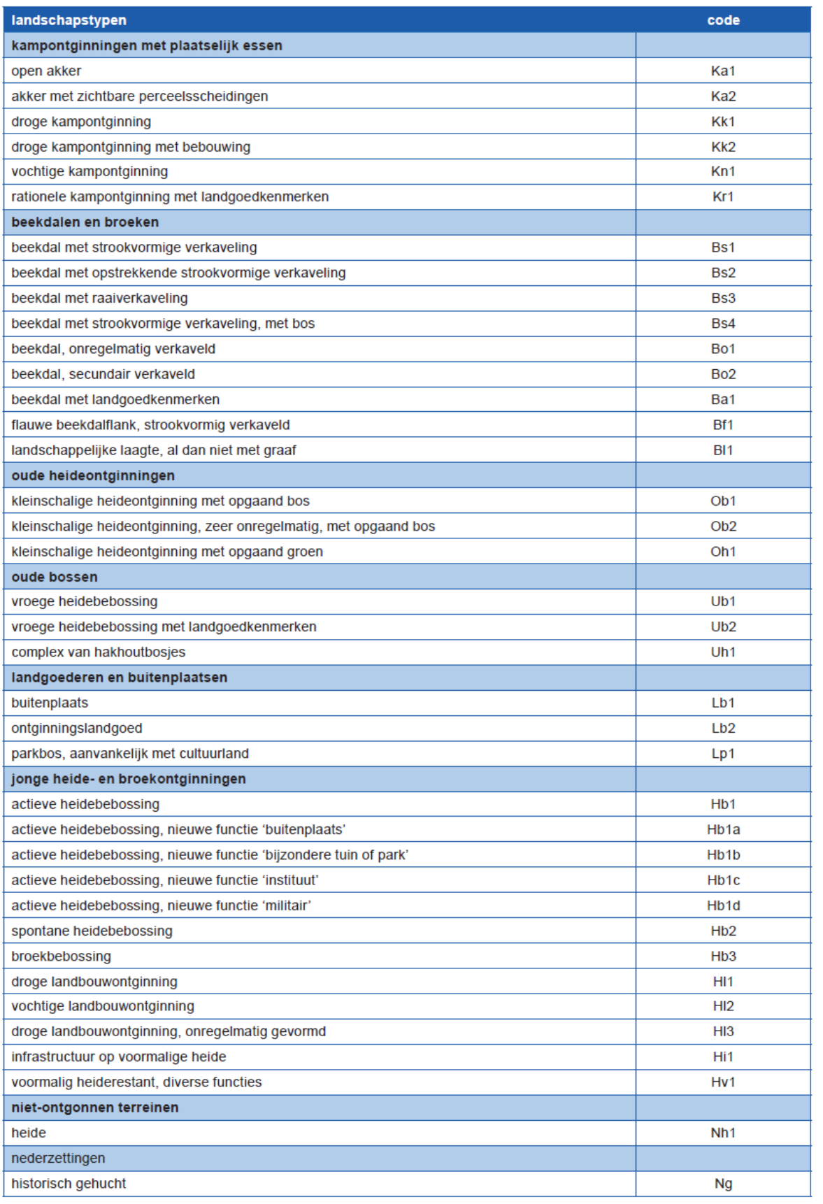
De landschappen en nederzettingen weergegeven op de kaart zijn onder te verdelen in de volgende landschapstypen:
Bij de elementen gaat het om de volgende zaken: infrastructuur, waterstaat, opgaand groen, religie en funerair erfgoed en reliëf.
Waardenkaart historische stedenbouw en gebouwd erfgoed
De cultuurhistorische waarden zijn onderscheiden in verschillende thema’s die als afzonderlijke lagen op de kaart zijn weergegeven (zie legenda). De gebieden zijn via een codeletter en een volgnummer gekoppeld aan een databestand van beschrijvingen en afbeeldingen. Op de digitale kaart in GeoFundament kunnen deze gegevens worden opgeroepen.
Op de kaart is onderscheid gemaakt in de volgende lagen.
- Stedenbouwkundige structuren (codeletter S): deze laag omvat zowel de historische stedenbouwkundige structuur als de aan historische wegen gerelateerde bebouwing. Tevens zijn beschermde stads- en dorpsgezichten die op grond van de Monumentenwet zijn aangewezen, hier te vinden (codeletter BS)
- Weg en waterstructuren: deze laag omvat de historische wegenstructuren waarbij onderscheid is gemaakt tussen die voor 1900 en na 1900 zijn aangelegd. Daarnaast zijn de rivieren, beken en kanalen hierin opgenomen.
- Landschappelijke en groenstructuren (codeletter L): deze laag omvat tevens agrarische nederzettingen.
- Archeologische verwachtingsgebieden (codeletter A): deze laag omvat de gebieden die voorkomen op de Archeologische Verwachtingskaart. De gebieden die zijn onderzocht, de gebieden die niet zijn onderzocht en de archeologische monumenten zijn verschillend aangegeven.
Verder zijn los van deze dataset op het portaal te vinden: Monumentale bomen (te filteren binnen https://data.eindhoven.nl/explore/dataset/bomen/information/) en Rijks- en gemeentelijke monumenten (zie https://data.eindhoven.nl/explore/dataset/monumenten/information/)
Dataset schema
JSON Schema
The following JSON object is a standardized description of your dataset's schema. More about JSON schema.